

The Yukon Geological Survey has released new aerial photographs taken in the mountains near the epicenter of the Dec. 6 magnitude 7.0 earthquake near Hubbard Glacier, documenting extensive landslide, avalanche, and glacial ice damage triggered by the seismic event.
YGS staff conducted the reconnaissance flight on Friday, Dec. 12, taking advantage of a brief weather window to reach the remote site. The objectives of the mission were to document landslide and avalanche activity caused by the earthquake, verify satellite-based observations, and determine whether the fault rupture reached the Earth’s surface. The information will help scientists refine estimates of the earthquake’s location, shaking intensity, and potential hazards for future backcountry travel.
Despite approximately two meters of fault slip occurring about five kilometers below the surface, survey crews found no clear evidence of surface rupture. YGS noted, however, that any surface expression of faulting may be concealed beneath glacier ice.
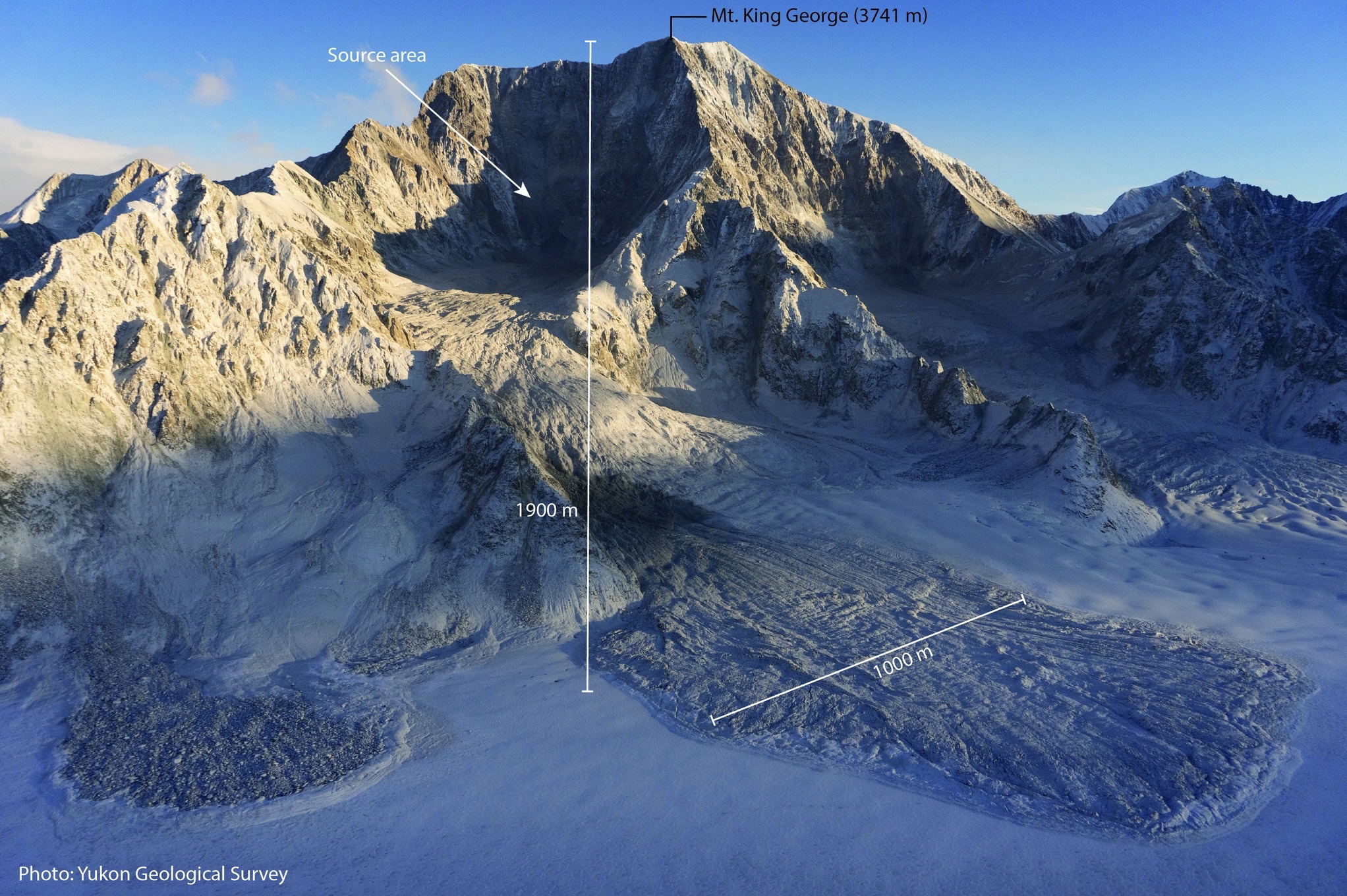
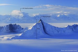
The earthquake triggered numerous large landslides, primarily on the slopes of Mt. King George, a 3,741-meter peak located roughly 40 kilometers east of Mt. Logan. Many of these landslides remain unstable. When the crew arrived in the area, dust clouds were still visible from a large slide that had recently occurred on the mountain’s east face. Smaller landslides were also observed on Mt. Vancouver, Mt. Logan, and nearby sub-peaks. There have been thousands of aftershocks associated with the Dec. 6 earthquake.

Snow and ice avalanches were more common farther from the earthquake’s epicenter. Preliminary analysis places the area of maximum fault slip and most aftershocks beneath or immediately adjacent to Mt. King George, suggesting the most intense ground shaking occurred there. The concentration of the largest landslides appears to align with that zone of strongest shaking.
In addition to rockslides, the earthquake caused widespread damage to glacial ice. Seracs and icefalls were fractured and toppled by the shaking throughout the region. Surveyors noted that the timing of the event likely prevented loss of life, as similar earthquake-triggered serac collapses and avalanches have caused fatalities during past mountaineering seasons. Persistent rockfall from landslide scars and destabilized ice features may pose new hazards for future mountaineering and skiing expeditions.
The Yukon Geological Survey is asking mountaineers and skiers who may have pre-earthquake photographs of Mt. King George to share them. Pre-event images will help scientists estimate total landslide volumes. Photos can be sent to geology@yukon.ca.
The Dec. 6 earthquake occurred just before noon and was felt across an estimated 500-mile radius. The epicenter was located near Hubbard Glacier, about 60 miles north of Yakutat, Alaska, and was approximately three-quarters of a mile inside Canada. Because the earthquake was shallow, ground shaking was especially strong within about 50 miles of the epicenter.
The closest seismic station recorded 21 seconds of strong shaking and 59 seconds of perceptible shaking.
Seismologists currently assess the rupture as occurring on a northern strand of the Fairweather Fault system, between the Fairweather Fault in Canada and the Totschunda Fault in Alaska. In 2010, a University of Alaska Fairbanks graduate student identified this section as the “Connector Fault,” a name later incorporated into the National Seismic Hazard Model in 2023.
More photos can be found at the UGS Facebook page at this link.