

By SUZANNE DOWNING
Alaska is ending the year under a barrage of extreme winter weather, with Southeast buried under record-setting snow, Interior communities bracing for extreme, life-threatening cold, and transportation disrupted from harbors to rail lines.
In Juneau, relentless snow and ice have forced widespread closures and emergencies. City and Borough of Juneau facilities remained closed again Wednesday after two days of “essential staff only” operations. Bartlett Memorial Hospital reported that all hospital facilities and clinics plan to resume operations today, Dec. 31, after being closed due to heavy snow.
The snow totals are historic. As of midnight, 74.9 inches of snow had been recorded at Juneau International Airport for December—making it the second snowiest month in the capital city’s recorded history. Out-the-road neighborhoods are reporting more than 60 inches of new snow and streets that are 3-feet-deep in snow, and impassible.

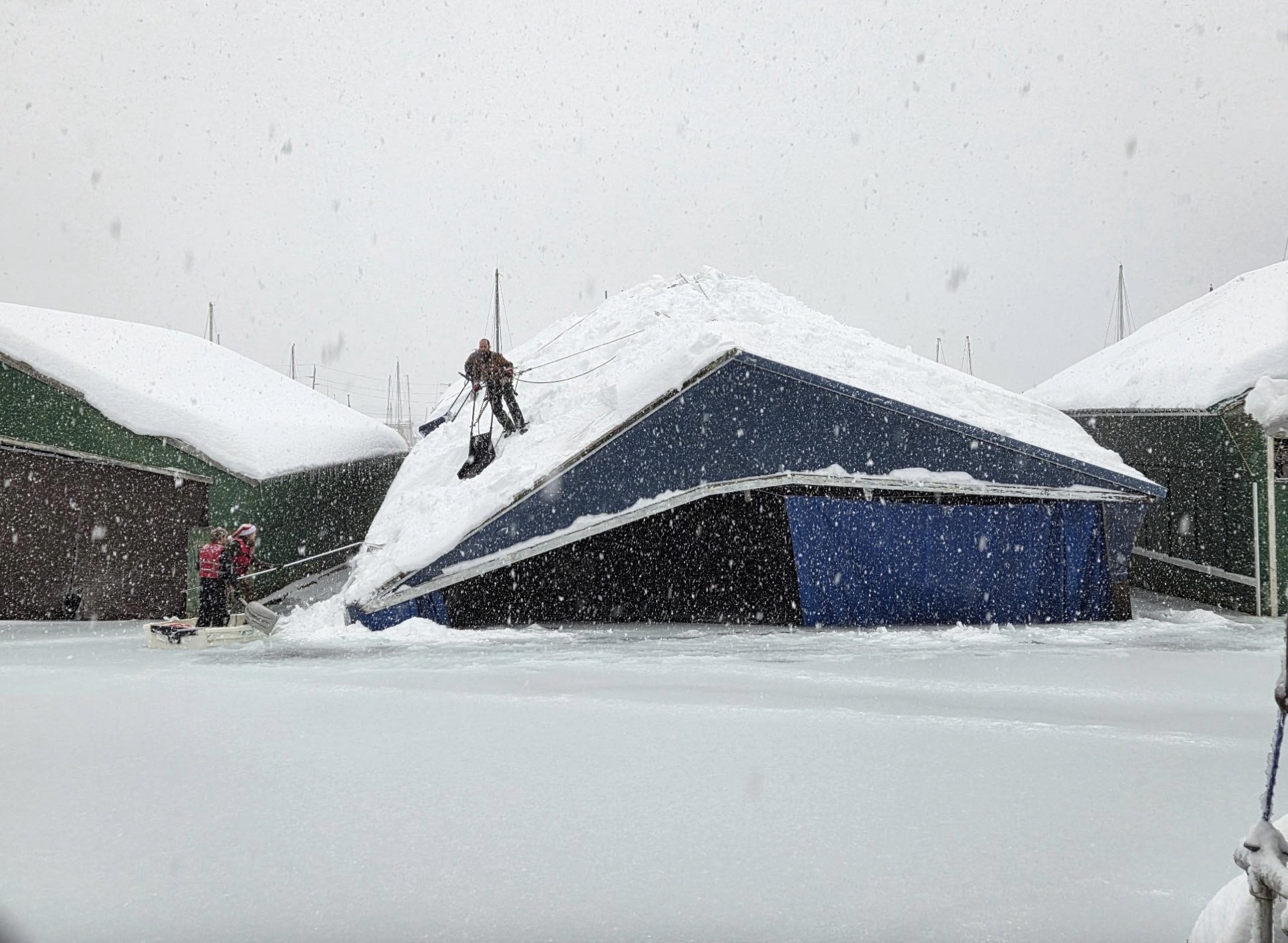
The weight of the snow is already taking a toll. Social media reports indicate multiple boats have sunk in Juneau’s harbors, and some buildings have suffered roof damage. The Juneau Harbor Department issued an urgent warning Tuesday morning, describing repeated layers of freezing rain followed by snow that have created extremely dense, water-laden accumulations on vessels.
“This is not light snowfall,” the department warned, noting that crews are responding to multiple sinking boats while being pulled away from snow removal on docks and walkways. Harbor officials urged all boat owners, regardless of vessel size or age, to clear snow and check bilge pumps as soon as it is safe to do so.
Power outages compounded the problems. Electricity was cut to customers near Eagle Beach and beyond Amalga Harbor Road, with restoration delayed until crews can safely patrol lines once roads are passable. Snow had not yet been plowed past Tee Harbor, slowing access for utility crews. Douglas Island also experienced outages.
Avalanche danger forced the closure of Thane Road at the avalanche gates Tuesday night at 8 pm, a closure that officials say could extend for days. The Alaska Department of Transportation and Public Facilities warned that if a natural avalanche reaches the roadway, debris may not be removable until conditions improve or mitigation work can be safely completed. Thane residents were advised to prepare for extended isolation.
Farther north, extreme cold is driving major operational changes. The Alaska Railroad announced the cancellation of the Aurora Winter Train for Jan. 3–4 due to dangerously low temperatures between Denali National Park and Fairbanks. To maintain essential flag-stop access for remote residents, the Hurricane Turn Train will still operate Saturday, Jan. 3.
In the Matanuska-Susitna Valley and across much of Southcentral Alaska, forecasters are warning of a sharp return to bitter cold beginning Thursday. Clearing skies and a colder air mass are expected to push temperatures well below normal through the weekend. Low-lying, wind-sheltered areas of the Susitna Valley—such as Willow—could see lows near -35°F. The Copper Valley is forecast to plunge to -35°F to -45°F, with wind chills approaching or dropping below -55°F. Anchorage, the Matanuska Valley, and the Kenai Peninsula could see lows between -5°F and -25°F, with daytime highs struggling to reach zero by the weekend.
In Fairbanks, the National Weather Service has issued a long-term Cold Weather Advisory lasting through the weekend and into Monday morning. Temperatures are expected to range from the mid-40s below zero to around 50 below by Friday night, with some valleys and typical cold spots east of Fairbanks potentially dropping to 60 below by Sunday night. Light or calm winds are expected to allow ice fog to redevelop, creating poor visibility and hazardous travel conditions—especially concerning for New Year’s celebrations.
Along the northern coast, the National Weather Service has issued a Winter Storm Watch for the Eastern Beaufort Sea Coast beginning Wednesday night through Thursday afternoon. Forecasts call for light snow combined with wind gusts up to 50 mph, potentially producing blizzard conditions and visibility as low as one-quarter mile.
From sinking boats in Juneau to rail cancellations and deep-freeze warnings across the Interior, Alaska’s weather is delivering a wallop as 2025 comes to a close: winter is firmly in charge, and caution is essential statewide.
Photo by Juneau Harbor Department of a boathouse collapsing under the weight of snow.


5 thoughts on “Year ends with wicked weather across Alaska”
Earth Weather cycles are normal. We just got spoiled from living under the warmer weather cycle and more predictable we had the last winters back.
If we visit Alaska history books there are photographs showing Alaskans in our past facing same extreme conditions which is likely it was photographed because of phenomenon. I think even during our 18th and 19th century ancestors winters they had warmer winters not as extreme as some.
What I noticed Climate Change is just natural earth cycles. Some years it gradually warms up before it gets colder and back around again.
But if cycles becomes more frequent and intense or more destructive at the same time it tells what Jesus said that before his second return, the storms will increase and intensify because his hour is drawing nearer.
Something that interest me and its affect against our earth’s water was after learning that the moon is gradually drifting away from us 3.8cm every year.
I think that would explain why some coastal or mountains places are losing water and some places are gaining water
So humans are realistically not affected the climate than the earth cycles and our moon are affecting us more than we affect it
Currently the temperature where I am is 7-8 degrees lower than the hourly forecast, there is a zero percent chance that we will reach the forecast high today as it is forecast to be 25 degrees warmer than it is now. The forecast for the coming days will most likely prove wrong once again and it will be much colder, so plan accordingly. Just more anthropogenic global warming, nothing to see here move along.
A forecast is nothing more than a photograph (metaphorically speaking) of observed weather indicators at a moment in time. The moment those observed indications are printed they have already changed. Expecting perfection in forecasting is naively unrealistic.
And yet they can’t get it right for the very hour they are currently forecasting. Given that they cannot accurately forecast the weather for the very hour they are forecasting, you’d think (well maybe not you) that the forecasting metaphorical photograph of observed weather indicators would be updated to include the actual observed weather. When the observed weather says it is 5, 10, or 15 degrees below what their forecasted weather said it would be, would it not be prudent to update the forecast? Nobody is expecting perfection, but when I look outside and it’s raining the “forecast” shouldn’t say it’s sunny, when I go outside and it’s below zero the forecast shouldn’t say it’s 15 degrees warmer than it is.
When a group of experts can’t be counted upon to use their eyes to read a thermometer, how can anyone take them serious while they predict the weather hours or days in advance when they are so frequently and completely wrong? How can these same experts be counted upon to make long term predictions about the climate when they fail time and time again? Nobody exp3cts perfect, but close would be a good place for these so called experts to start.