


By SUZANNE DOWNING
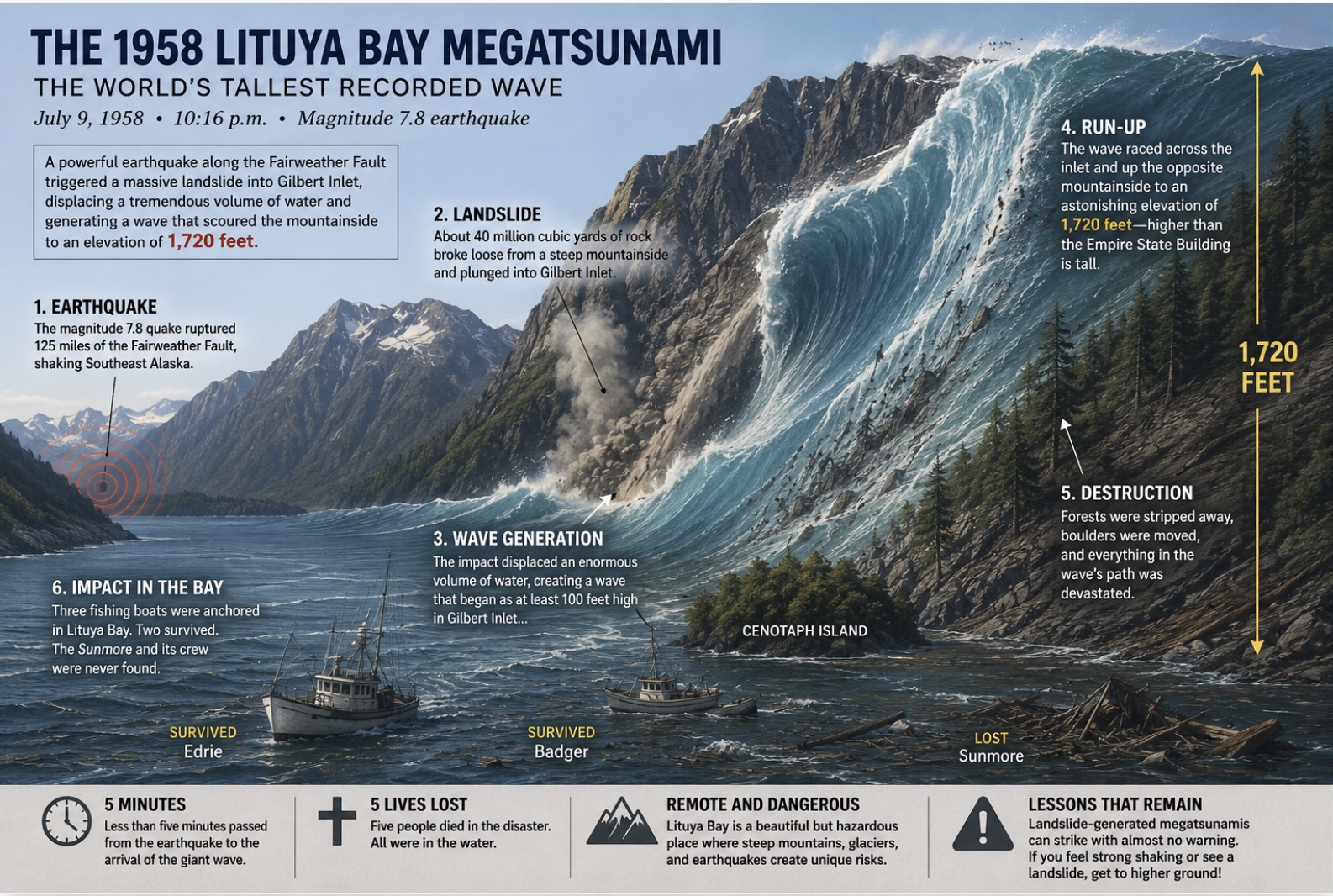
July 9, 2026 – Sixty-eight years ago today, on the evening of July 9, 1958, one of the most extraordinary natural disasters in recorded history unfolded in a remote corner of Southeast Alaska. A powerful earthquake along the Fairweather Fault triggered an enormous rockslide into Lituya Bay, creating the largest wave ever documented on Earth. It was a towering wall of water that stripped mountainsides bare to an elevation of 1,720 feet.
The event remains the benchmark by which all other megatsunamis are measured.
Lituya Bay, located about 100 miles northwest of Juneau near Glacier Bay National Park, is a narrow, T-shaped fjord carved by glaciers. Surrounded by nearly vertical mountains and fed by glaciers at its head, it has long been known as a place of both breathtaking beauty and extraordinary danger.
Long before scientists understood why, the evidence was etched into the surrounding hillsides. Distinct “trimlines” marked where previous giant waves had scoured away mature forests, leaving younger trees below. U.S. Geological Survey geologist Don Miller had identified evidence of at least four massive waves during the previous century, but their cause remained a mystery.
That mystery was answered on July 9, 1958.
At 10:16 pm, a magnitude 7.8 earthquake ruptured approximately 125 miles of the Fairweather Fault from Palma Bay to Icy Bay. While the quake caused relatively modest structural damage in communities such as Yakutat, its greatest destruction occurred inside isolated Lituya Bay.
About 40 million cubic yards of rock broke loose from a steep mountainside overlooking Gilbert Inlet and plunged almost directly into the water below. The tremendous impact displaced an enormous volume of water, launching a wave unlike anything previously observed.
Across the inlet, the surge blasted vegetation, soil, and even bedrock from the mountainside, leaving a clean scar reaching 1,720 feet above sea level.
To put that into perspective, the wave climbed higher than the Empire State Building is tall.
Fortunately, the immense wave was concentrated within the narrow confines of the bay rather than spreading across the Pacific Ocean like a conventional tsunami.
Three fishing boats were anchored inside Lituya Bay that evening.
Howard Ulrich, aboard the Edrie with his 7-year-old son, survived after steering directly into the approaching wall of water. His boat rode over the crest before eventually escaping through the bay’s narrow entrance.
Another couple aboard the Badger was lifted over a narrow spit of land before their boat sank. They survived by escaping in a small skiff.
A third boat, the Sunmore, disappeared entirely. Its owners, Orville and William Wagner, were never found. Five people lost their lives during the disaster.
When geologist Don Miller surveyed the bay afterward, the devastation was almost beyond belief. Entire forests had vanished. Massive rafts of logs floated miles offshore. The lighthouse at Harbor Point had disappeared. The mountaineering camp that had occupied the shoreline only hours earlier had been scoured down to bare bedrock.
Many scientists initially doubted Miller’s measurements. A 1,720-foot wave seemed physically impossible.
Subsequent research proved him correct.
Laboratory modeling beginning in the 1960s and continuing into the 21st century demonstrated that a rapidly moving landslide entering a confined fjord can generate an enormous air cavity and water displacement, producing what scientists now call a megatsunami. While researchers continue to debate some details of the event—including whether an underwater slide contributed to the wave’s size—the essential findings have stood the test of time.
The 1958 disaster fundamentally changed scientific understanding of landslide-generated tsunamis.
Just six years later, the magnitude 9.2 Great Alaska Earthquake would trigger numerous deadly local tsunamis caused by underwater and landslide failures throughout Southcentral Alaska.
The lessons continue today.
Southeast Alaska remains especially vulnerable because it combines steep mountains, active glaciers, heavy rainfall, unstable slopes, and frequent earthquakes. In 2015, a massive landslide into Taan Fjord generated another megatsunami with a run-up exceeding 600 feet. Fortunately, few people were nearby.
Unlike ocean-wide tsunamis that can often be tracked for hours, landslide-generated megatsunamis offer almost no warning. In Lituya Bay, less than five minutes passed between the earthquake and the arrival of the giant wave.
For that reason, emergency planners emphasize a simple rule: If you’re near the water in coastal Alaska and experience strong ground shaking or witness a major landslide, move immediately to higher ground.
Today, nearly seven decades later, the scar left by the world’s tallest recorded wave remains visible from the air, and is a stark reminder that Alaska’s dramatic landscapes were shaped not only by glaciers and time, but occasionally by moments of astonishing geological violence.



2 thoughts on “Anniversary of Alaska’s giant wave: The 1958 Lituya Bay megatsunami remains the tallest ever recorded”
There was another megatsunami in Tracy Arm south of Juneau last year, it was one of the largest ever recorded. A much small but similar event occurred near Aialik Bay outside of Seward in 2024.
The story told by the survivors of the Lituya Bay megatsunami are incredible. Seeing a wave crash over sitka spruce that are well over 100 feet tall on an island would be an apocalyptic vision.
Thank you for the “tall” tale, Suzanne. One with which I was not, heretofore, familiar.