

By THE ALASKA STORY
March 19, 2026 – As much of the northern hemisphere begins to thaw, Alaska is preparing for a seasonal turning point that arrives on paper this Friday, even if winter refuses to let go just yet.
The spring equinox on March 20 marks the official start of longer days across the state, with daylight continuing to stretch rapidly in the weeks ahead. For many Alaskans, it’s a psychological milestone as much as a scientific one, a sign that the long, dark winter is finally loosening its grip.

But in parts of the Interior, it may not feel like spring anytime soon.
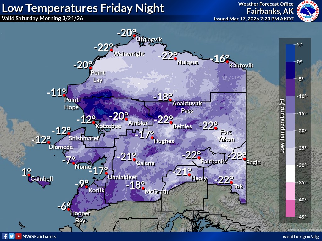
At Fairbanks International Airport, temperatures plunged to -40°F again on the morning of March 18, marking the 31st time this winter the mercury has hit that threshold. That places this season fourth on record for the number of -40°F readings and ties for the third-latest occurrence of such extreme cold.
For perspective, -40 degrees is the only temperature at which the Fahrenheit and Celsius scales meet, a point Interior residents have now seen repeatedly this season.
Even as the cold lingers, the rhythms of spring are beginning to stir. Bears will soon emerge from hibernation, and migratory birds are expected to begin their return north to breeding grounds across Alaska.
Beneath the surface, however, conditions are aligning for a potentially challenging spring breakup season.
The Alaska-Pacific River Forecast Center has issued its first Spring Breakup Outlook for 2026, warning of an above-average potential for flooding across much of Interior Alaska. Rivers including the Yukon, Tanana, and lower Kuskokwim are of particular concern.
The elevated risk is driven by a combination of factors: above-average snowpack across key basins, thicker-than-normal river ice following the prolonged cold, and reports of high freeze-up levels and rough ice conditions in several regions.
In contrast, forecasters say breakup flooding risk is lower in the Koyukuk River basin and parts of Southcentral Alaska, where snowpack levels are below average.
How the season ultimately unfolds will depend heavily on spring temperatures. Early guidance suggests April — and possibly May — could bring average to above-average warmth, which would favor a slower, more gradual snowmelt and reduce the likelihood of severe flooding.
However, forecasters caution that a different scenario: A cold April followed by a rapid warmup in May could trigger fast snowmelt, increasing the risk of dynamic river breakups and dangerous ice jam flooding.
For now, Alaska stands in transition. The calendar says spring arrives Friday, yet the thermometer, at least in some parts of the state, still says winter.
The next Spring Breakup Outlook by the National Weather Service is scheduled for release on April 10.


4 thoughts on “Spring Equinox is Friday, but some parts of Alaska remain in the deep freeze”
YOU ARE NOT ALLOWED TO PUBLISH THIS INFORMATION! Pretty soon, the artic ice will be back and polar bears will not be dying. Please Please stop this misinformation. Al Gore was right, cover your ears and mouth and look away.
As soon as the temps in the Interior hit +40°, the climate activists will emerge from their closets.
It’s unusually ‘HOT’ here in Scottsdale (AZ) … and, it’s only mid-March!
Fairbanks broke a record this winter for number of consecutive days with a high temp below zero. The previous record of 30 days, set in 1953, was broken by a 32 day streak between Dec. 14th and Jan. 14th.