


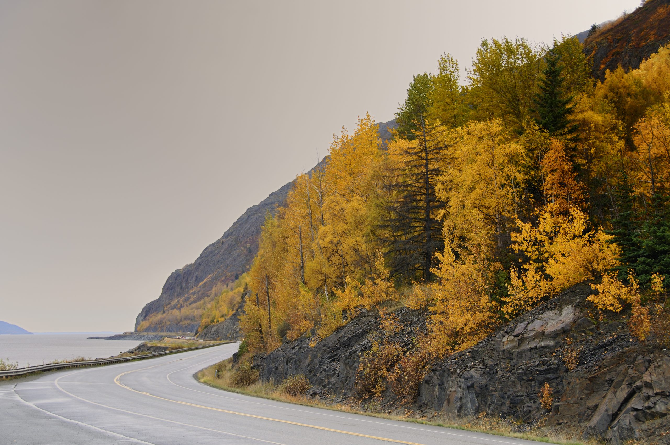
The stretch of Seward Highway skirting Turnagain Arm is known for its sweeping views and sudden hazards. Tight curves, narrow shoulders, heavy seasonal traffic, and a lack of separation between opposing lanes have made this corridor prone to severe crashes for decades, earning it the state’s first Highway Safety Corridor designation and prompting renewed efforts to permanently change the way the road is built.
The Alaska Department of Transportation & Public Facilities has released the Draft Environmental Assessment and Draft Individual Section 4(f) Evaluation for the Safer Seward Highway Project, making them available for public review through February 12, 2026, on the project website and at the Anchorage Loussac and Girdwood Libraries.
The draft documents analyze proposed safety and mobility improvements on the Seward Highway between mileposts 98.5 and 118, the roughly 20-mile corridor from Bird Flats to the Rabbit Creek Road intersection, and are part of the state’s process to comply with the National Environmental Policy Act and related federal environmental requirements, including the US Department of Transportation Act Section 4(f).

The Draft EA explains that the purpose of the project is to reduce crash rates and crash severity, improve mobility and reliability for all users of the corridor, and safely accommodate mixed uses, including motorized vehicles, bicyclists and pedestrians. The Existing roadway is largely a two-lane rural arterial constrained between Turnagain Arm, the Chugach Mountains and the Alaska Railroad, with limited shoulders, tight curves and few safe passing opportunities. This section of the Seward Highway was designated Alaska’s first Highway Safety Corridor in 2006 due to persistent high crash rates and severity despite enforcement, education and earlier safety efforts.
The proposed action is to reconstruct the corridor as a four-lane divided highway with a design speed of 55 mph, including median barriers or vertical separation between opposing travel lanes and a separated multi-use pathway for non-motorized users.
The reconstruction would straighten six curves between mileposts 105 and 110 and add new multi-use pathway connections where none currently exist, as well as expand parking at key scenic and recreational pullouts such as Beluga Point, Rainbow Trailhead and Windy Corner Trailhead. The project would also consolidate many small pullouts and access points to improve safety and access management. Improvements to drainage, culverts, signage and frontage roads are also included.
The draft environmental assessment notes that the Seward Highway corridor within the project area serves a variety of users, including local residents, tourist traffic, commercial vehicles, and recreational visitors accessing trailheads, scenic overlooks and recreational sites.
Traffic mobility can deteriorate during peak summer weekend volumes, with slow platoons of vehicles forming behind slower traffic, often recreational vehicles, and result in frustrated drivers attempting risky passing maneuvers due to limited opportunities. Emergency access to and through the corridor during crashes, rockfall, or avalanche events is constrained by the two-lane design.
The environmental analysis in the draft EA evaluates potential effects of the proposed action on physical, biological and human environments, including wetlands, vegetation, wildlife, waterbodies, cultural resources, land use and socioeconomic conditions, with opportunities for comment on minimization and mitigation measures.
Members of the public are invited to attend scheduled public hearings in Girdwood on Jan. 13, Anchorage on Jan. 14 and Indian on Jan. 15 to review the draft EA and provide testimony. An online open house will also be available Jan. 13–28 for those who cannot attend in person. Comments on the draft EA and draft Section 4(f) evaluation must be submitted by Feb. 12.


5 thoughts on “Scenic and deadly: State moves forward on Safer Seward Highway Plan”
SaferSewardHighway.com is the website.
Build a Homer spit like causeway from bird creek south to shortest distance over near Hope. Complete that road all the way to Kenai.
Camping on the new spit??
Tourist have to drive to old way around.
Would be fun to watch during a bore tide. 😀 An elevated structure might prove more appropriate….
A few years ago in mid December about 4 PM my wife and I were stopped for 6 hours on the Seward Hwy as we were driving into Anchorage from Soldotna just south of the Portage Road turnoff because there was a bad accident involving the death of a woman. I don’t know the particulars, but what I heard was that someone was turning off of the highway and got hit. So, there are problems with drivers even after/before the area next to the cliffs. There were probably more than 100 vehicles stopped on the highway. I saw a steady stream of headlights and taillights once we got moving and I could see no advantage to try to get ahead of anyone else going into Anchorage, yet some drivers were passing constantly trying to get ahead. A 4 lane divided highway is really needed especially in the area around the cliffs.
Not sure how they are going to make it two lanes without moving a LOT of rock. Maybe a bridge across Turnagain Arm to the Kenai Peninsula just before McHugh Creek to reduce congestion? I’ve long advocated for some sort of divider between the lanes that makes passing in the oncoming lanes impossible. Irresponsible passing is the killer on this highway. Also, I always move into the right lane where same direction passing is available and usually stay at 55 MPH so those hurried individuals who just must pass can do so at 65 MPH without hitting extremely high speeds. I suggest putting up speed limit signs to indicate a “dual speed limit” wherever installation of passing lanes is feasible.