


By THE ALASKA STORY
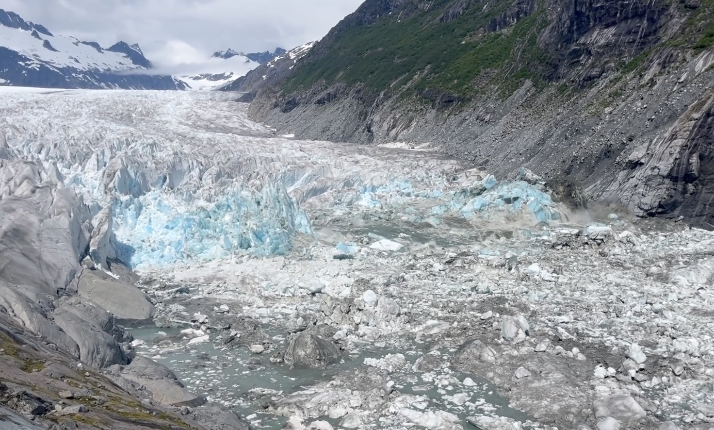
Aug. 11, 2026 – A glacial outburst has begun at Suicide Basin, triggering an evacuation advisory for parts of Juneau’s Mendenhall Valley as officials prepare for flooding along Mendenhall Lake and River.
The City and Borough of Juneau announced Tuesday that the ice-dammed basin is releasing. Flooding is expected to reach the Mendenhall Lake and River area late Wednesday evening and continue into early Thursday morning.
Residents within the mapped evacuation advisory area are being advised to leave Wednesday, Aug. 12, and remain away until floodwaters recede and officials issue an “All Clear” through CBJ Alerts and other official channels.
The release marks a significant change from the warning issued earlier Tuesday, when officials reported that Suicide Basin was full and could begin draining within one to six days. Residents were told at that time to finalize preparations, confirm evacuation plans and prepare go-bags.
An American Red Cross emergency shelter will open Tuesday evening at Floyd Dryden Middle School’s gymnasium, 3800 Mendenhall Loop Road. Limited space will be available for pets. Juneau Animal Rescue is also offering emergency pet sheltering through its Safe-Keeping Program.
Officials have established recommended evacuation routes to reduce congestion and avoid possible road or bridge closures.
Residents north of Division Street should travel north on Riverside Drive toward Mendenhall Loop Road and out of the potential inundation area. Those south of Division Street should travel south on Riverside Drive and turn left onto Stephen Richards Memorial Drive toward Mendenhall Loop Road.
Residents on Rivercourt Way should travel south on Riverside Drive toward Egan Drive. Those on the west side of the Mendenhall River should travel west on Mendenhall Loop Road toward Auke Bay and avoid the Back Loop Bridge. Residents west of Brotherhood Bridge should travel west on Glacier Highway toward Auke Bay.
Officials warned residents not to approach the river or attempt to drive through flooded roads. Although flood barriers have been installed to protect vulnerable neighborhoods, flooding remains possible.
If a flash flood occurs, residents still inside the evacuation area may not have enough time to leave and should shelter in place, according to the city.
Approaching the river during the flood warning could endanger residents and first responders while interfering with evacuation traffic. Live camera feeds monitoring the lake and river are available through the city’s flood information website.
Suicide Basin is a side basin of the Mendenhall Glacier that fills with meltwater until pressure forces water beneath the glacier and into Mendenhall Lake and River. The recurring glacial lake outburst floods have become increasingly destructive in recent years.
In August 2025, the Mendenhall River reached a record crest of 16.65 feet, causing major flooding in the valley. Local, state and federal agencies have since expanded monitoring and installed barriers in an effort to protect homes and infrastructure, but officials stress that the barriers do not eliminate the danger.
The Flood Information Hotline is operating around the clock at 907-500-0890 for questions and non-emergency concerns. Anyone facing an immediate threat to life or safety should call 911.
Evacuation maps, shelter information, pet requirements and live monitoring cameras are available at JuneauFloodReady. Residents can register for emergency notifications through CBJ Alerts or by texting “CBJ” to 38276.


11 thoughts on “Breaking: Suicide Basin releases; Juneau residents in flood zone advised to evacuate ahead of expected flooding”
The poor liberals of the Mendenhall valley neighborhoods they don’t need to continually expect this as this flooding is becoming a common event. Alaska these common disasters is the consequence of electing people who can’t read or they are illiterate into leadership and managerial positions. They don’t know how to think and can’t think and take corrective actions out of a problem. The poor Juneau neighbors affected. Neighbors either will be smarter and elect more conservative neighbors or they’ll abandon the neighborhoods affected and move to a new neighborohood. Good chance the liberals will move from their old neighborhood before changing who they vote for.
They are going on six years and nothing has been done except sandbags
Too bad it won’t wash away the Senate. It could use the cleanout
All contour lines on maps are legally defined by North American Vertical Datum (NAVD) which is based upon Mean High Water level as reference-0. An apparent quote from government says, “In August 2025, the Mendenhall River reached a record crest of 16.65 feet….” Obviously, the quote meant to say Mendenhall Lake–not River. However, since the Juneau Airport is at elevation 28-feet we know the lake could never be elevation 16.65-feet. The fact is, Mendenhall Lake is normally about 53 to 56 feet above sea level (MHW). Anyone can see the relative legal elevation of their driveway by referring to Google Earth. Therefore, the so-called experts should properly be telling us how high the lake is in proper nomenclature. If they did so, everyone could have a better idea of how the lake elevation relates to their front yards. Why does your government insist on communicating in indiscernible code? Just saying.
To be clear, Mean High Water Level (MWH) is generally considered Sea Level. Its accepted as international reference basis for elevation. For example, the summit of Mt McKinley is 20,310-ft… above sea level that is. It would be foolish to the world it was 16.65-ft above a random benchmark other than sea level.
To be clear, Mean High Water Level (MWH) is generally considered Sea Level. Its accepted as international reference basis for elevation. For example, the summit of Mt McKinley is 20,310-ft… above sea level that is. It would be foolish to tell the world it was 16.65-ft above a random benchmark other than sea level.
Gage height is the distance (or height) of the water surface above the stream gage datum reference point. The gage datum is a uniquely selected reference point for each gage site. Most of the time, it is picked to be below the lowest anticipated depth of a stream or lake because streambeds change over time. At some locations, this arbitrary reference point may be picked to coincide with sea level.
People often understand what water height measurements mean to them; they know how gage height relates to benchmarks and landmarks in their area. Discharge, which is sometimes called streamflow or water flow, is defined as the rate at which a volume of water passes by a particular location. Discharge and gage height are related values. Complex math is used to compute the relation between gage height and discharge. It is easier to continuously measure the height of water than a volume of water passing by a point, so gage height is the parameter that is reported continuously and is used to compute the related discharge. Another reason that gage datums are picked to be below streambeds is related to the mathematical computations that relate gage height to discharge.
Oh look, people who built/bought house on a flood plan are in danger of being… flooded.
“Duh”, seems like to light of a sentiment here.
They won’t blame themselves for buying homes in a flood plain, but blame it on global warming. Prepare yourself for tearful testimony before the legislature (which is conveniently located just 20 minutes away) about how we need 1) more carbon sequestration, 2) more federal dollars to build a levee 3) more stringent controls on just about everything to reduce our “carbon footprint” and 4) elect more Democrats so we can join the Green New Deal.
Lots of warm thoughts for your fellow Alaskans as usual. Keep it classy. But let’s clear something up right now. Many homes were not considered in a flood zone until 2024. My friend’s uncle bought an upstairs/downstairs duplex. When he bought the house in 2004, his insurance company told him he wasn’t in a flood zone and he didn’t need flood insurance. My friend, his wife, and 4 children barely made it out alive in 2024. The flood came in the middle of the night. They lost pets, ashes of a baby, every single thing they owned. Because that water went all the way to the ceiling of that lower level within minutes. Ice water – 2AM. The family evacuates to my home now. The youngest children still will only sleep on the floor no matter where they are because “if the cold water comes back I’ll have more time to get out”. Anyway, I’ve got work to do. Doing a fundraiser event for a conservative tonight, while hosting this large family… got some cooking to do.
Seems to be a lot of 100 year natural disasters in that area in the last 5 years l! Let’s double down and roll the dice again!
Keep it classy, people. Have a little humanity. For those that don’t know, most of these homes were built in the 1970’s and 1980’s. Some of the ones that were damaged the worst were NOT in a known flood area. I know someone who bought his home in 2004. The insurance company told him he did not need flood insurance. Actually many of these people were told they didn’t need insurance. It’s a two story duplex. One up, one down. My friends, a young family with children, barely made it out alive when the entire apartment flooded to the ceiling, in the middle of the night, no warning. They lost everything, including pets, and the ashes of a baby. That family now evacuates to my house. The youngest two children still will not sleep on a bed, because they say “I’m short. If the water comes I need more time to escape, so I only sleep on the floor”. Anyway, I’m hosting a fundraiser for Republican Annette Kreitzer this evening, so I need to get back to the kitchen.